
Navigation Marks
Published · Updated
This story has been restored from the magazine archive. The text is original; outdated contact details have been removed.
Anyone sailing in the Archipelago should know the most important rules of navigation.
One must at all times remember that shipping is always to have priority. According to the harbour police there have been problems on narrow passages like the inlets of Turku and Naantali harbours in the last few years. Trolling boats and other small watercraft have not clearly enough given way to car ferries, cargo vessels and tankers. A two-hundred-metre swimming hotel cannot be as nimble as a four-metre open boat. If these disturbances do not cease they will inevitably result in restrictions on fishing near the waterways.
Familiarity with the navigation marks is the prerequisite of a successful fishing trip in the Archipelago. There are two reasons for it: first passing the mark on thewrong side may damage the propeller or cause extensive damage to the boat or the engine. Secondly, the navigationally wrong side of the mark is ofen a shoal where the perch feed.
There are two main types of navigation marks. The Lateral Marks are green and red buoys between which the safe route leads. On the navigation chart you can see, which is the right (green) and which is the left (red) side of the passage. The Cardinal Marks indicate the quarter where the route is situated. There are four of them to denote the Cardinal Points and a fifth to mark a rock you can pass by on any side as long as you don´t head straight at it.

ROCKMARK
Pass by on any side
THE CARDINAL MARKS
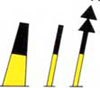
The safe route is situated north of the mark.

THE SOUTH-MARK
The safe route is situated south of the mark.

THE WEST-MARK
The safe route is situated west of the mark.

THE EAST-MARK
The safe route is situated east of the mark.
THE LATERAL MARKS

THE RIGHT- MARK (green)
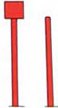
THE LEFT-MARK (red)